
Street Report | March 10, 2026
From late afternoon into the early morning hours, the streets showed what happens when weather, crime, drugs, and failing infrastructure collide.
While the radio carried updates about the expanding U.S.–Iran war, rising gas prices, and tornado watches across the Midwest, the streets of Chicago told a different story.
Overdoses near the Red Line. Police writing tickets while serious calls stacked up on the scanner. Drug conversations under viaducts.
Hail hammering cars. Drains that don’t work. Migrants standing in storms outside shelters. Streets flooding around one of the city’s biggest hospitals.
On the ground, the story looked very different.
The afternoon began downtown in Streeterville and along the Magnificent Mile.
Streeterville once functioned as Chicago’s vice district — gambling houses, brothels, and taverns built on landfill after the Great Chicago Fire. Even then the pattern was familiar: people built something valuable, and the city eventually tried to control it.
Driving through the area today reveals a different kind of decline. Storefronts that once held some of the most expensive retail leases in America now sit empty.
“For Rent” signs hang in windows that once displayed designer brands.
Police patrol the sidewalks in visible groups, a show of presence in areas where the deeper problems—economic decline and rising crime—remain unresolved.
Uniforms walking past empty storefronts do not rebuild a downtown economy.
Patrolling the Magnificent Mile while violent crime continues in other parts of the city raises questions about how police resources are being deployed.
Around five in the afternoon the quiet downtown scene shifted. Multiple squad cars and a transport wagon pushed into the Loop and converged on Block 37 just as rush hour traffic filled the streets.
A suspect was taken into custody and put into a wagon at Block 37. Police vehicles blocked lanes while officers stood in the street, and traffic stacked up around them.
At the same time, the police scanner carried a steady stream of calls from across the city: a person with a gun near Wilson and Broadway, a battery in progress near Ashland and Montrose, and a man smashing bottles and acting erratically on the State and Lake Red Line platform during rush hour.
Once the man boarded a train, interest in that call faded.
Moving down to the Roosevelt Red Line station reflected another side of Chicago’s public safety reality.
Roosevelt has become one of the most consistently dangerous stations in the transit system, a location where overdoses, robberies, assaults, and occasional murders have become familiar.
On this afternoon another apparent overdose call brought Fire Department Ladder Truck 1 to the station.
The truck is one of the largest and most expensive pieces of emergency equipment in the city, designed for fires and major rescues. Instead it sat outside the station responding to what appeared to be another narcotics emergency.
Overdose victims require help, but when large fire units repeatedly respond to predictable drug scenes while other emergencies compete for resources, the strain on the system becomes obvious.
From overdoses on the platform to the supply moving through the streets, the next stop revealed another layer of the problem.
Leaving the downtown corridor later in the evening led west toward the viaducts and industrial stretches where Chicago’s street drug economy often unfolds in the open.
Two unhoused men were hanging out near the abandoned Blommer Chocolate Factory, talking openly about what’s circulating through the city’s street drug supply.
One of them opened a small chewing-tobacco container and held it up.
Street users call what was inside “dog food,” a term commonly used for heroin.
The explanation that followed sounded more like a street seminar on narcotics than a casual conversation. Dog food meant heroin. Straight fentanyl was something else entirely.
“If they say straight fentanyl, you don’t want that,” one user explained. “You just need a little bit. Too much and you’re dead.”On the street, a usual hit was a five-dollar share split between two people and injected, not smoked.
From there, the talk turned to Narcan and fentanyl test-strip machines showing up in public spaces like libraries.
What worried them most was residue—fentanyl on hands or clothing that could rub off onto surfaces other people, including kids, might touch.
“Just touching it, you’re too high,” one man said. “What are you going to say when your kid’s high?”Another voice joined the discussion and mentioned methamphetamine—“Tina”—along with politics.
Forget campaign slogans about the past, he said. We need a new one:
“Make America Powerful”Around six fifteen that evening the weather changed quickly.
Hail began striking cars and pavement hard enough to send drivers searching for cover. Vehicles lined up beneath a viaduct while the storm intensified.
Even a squad car waited under the bridge.
Ice hammered the roadway for several minutes before the storm shifted back to heavy rain.
Once the hail moved through, the next problem appeared almost immediately.
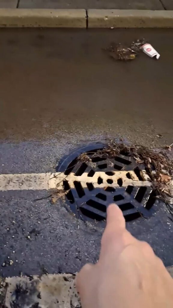
Driving west along Lake Street revealed large pools collecting along the curb lines. Storm drains sat submerged with little visible movement of runoff. Intersections filled quickly despite the storm lasting only a short time.
At Lake and Oakley the reason became clear.
A bicyclist suddenly moved out of the bike lane and into traffic. Passing the intersection revealed why.
The bike lane had filled with standing water.
Closer inspection showed the storm drain sitting nearly two feet away from the curb gutter—the channel where rainwater naturally flows.
With the protected bike lane barrier in place, runoff could not reach the drain.
The drain had been left where the old curb line sat.
Instead of following it, the curb moved. Water now flowed along the gutter, hit the raised concrete of the bike lane separation, and stopped.
With nowhere to go, stormwater simply stacked up.
It was a predictable, visible outcome: the bike lane flooded, the car lane flooded, and the drain, though physically present, was functionally useless.
Sometimes the easiest way to spot a design failure is to watch what people do. The bicyclist already knew the lane didn’t work.
Don’t need a PhD to see somebody fucked this up.
These were not the consequences of an unprecedented storm. They were the consequences of design decisions. Someone had signed off on a street redesign without correcting for where gravity would take the water.
Fixing this will not be as simple as repainting or patching. Real correction would require tearing up newly poured concrete, reopening access to the sewer line, and rebuilding the interface between curb, gutter, and drain.
In a city already struggling with basic repairs, undoing a fresh mistake will be expensive.
Farther west along Lake Street and then south on Western Avenue, the pattern repeated in different forms.
On some corners the water was ankle-deep. Cars slowed to avoid spraying pedestrians or hydroplaning through intersections. One block later, the pavement was almost dry.
Where curb ramps had been cut into corners to comply with accessibility standards, they disappeared under brown standing water. What should have been safe access points for people with mobility issues instead became hidden slip hazards.
Abandoned and underused Chicago Housing Authority buildings sat within sight of flooded streets, their stairwells and boarded windows a reminder of how long some areas have gone without serious investment.
Flooding did not cover every block. It appeared in pockets, expanding where inlets were clogged or curbs crumbled and pulling back where someone, at some point, had maintained the basic drainage.
If this were purely a matter of overwhelming rainfall and citywide sewer capacity, the water would have spread more evenly.
Instead, neglect determined who got flooded and who did not.
At Western and Blue Island, a major intersection near a community college, city offices, and the county jail, the lights went out.
Traffic signals that normally control one of the corridor’s busiest crossings fell dark in the rain.
On one side of the intersection, water covered lanes and swallowed curbs. On the other, the street was damp but passable.
Drivers navigated the crossing by instinct and habit, inching through the darkened intersection while rainwater pushed against their tires.
Over the sound of the wipers, the police scanner crackled with a report of a robbery in progress nearby. The caller described screaming.
Later in the night, south and east of Western, a different type of vulnerability appeared around the migrant shelter near 23rd and Halsted.
Rain continued to fall as runoff collected in gutters and pooled near the curbs. Under tents and makeshift coverings, groups of people stood outside the shelter building.
They were mostly Venezuelan migrants.
Despite the weather, some remained in the open. The scene included drug use and small-scale dealing visible from the street.
After midnight, the storm’s effects showed up in yet another critical area: the hospital district in Streeterville.
Near Superior and Fairbanks, by Northwestern Memorial Hospital and the medical school, deep water covered parts of the roadway.
This is one of the most important medical corridors in the city.
Yet in the wake of a single evening’s storm, access routes were pocked with pools that forced vehicles and pedestrians to pick their way through uncertain depths.
The hail melted. The water eventually drained or evaporated.
The way the city is run remained.
Tuesday, March 10, 2026 did more than bring a storm.
It stripped away excuses.
Rain, rain, rain—the corruption did not wash away.
Image: Lake & Oakley – Chicago built the bike lane but left the storm drain almost two feet away from the curb gutter where water actually flows. One storm and the lane floods while the drain sits useless · 6:55 p.m. March 10, 2026 — SubX.News®
Editor’s Note: This report is based on a live drive on March 10, 2026, covering Streeterville, Mag Mile, South Loop, the Loop, the abandoned Blommer Chocolate Factory, Fulton Market, Kinzie Corridor, Lake Street, Western Ave, Cermak, Halsted, live broadcast radio, police traffic, and independent scanner feeds: https://youtu.be/mr0Um97Mqd8
SubX.News® – On-the-Spot Reporting
What did you see? Drop your own sightings, photos, and street reports below.
Tag #SubXStreetReport so we can track what City Hall misses.